

In the ever-evolving landscape of climate change, geospatial science emerges as a key player in navigating the complexities of our transforming world. The European Association of Aerial Surveying Indu...

Looking for a recipe for business success in surveying? Don't underestimate the importance of innovative surveying services, says Moritz Lauwiner. The latest measurement sensors and software, decades ...

Despite some uncertainty, there is renewed interest in drones, and remote sensing technologies are being embraced by smaller survey companies. Read these and other findings from our annual industry su...

3D visualization is at the heart of many geospatial data applications. Progress in 3D visualization has drastically reduced barriers to entry for new products based on large datasets, thanks to improv...

As we enter the era of smart manufacturing, the reliability of data is growing in significance and data standardization is becoming increasingly important. According to JP Kelly, associate director an...

A topobathymetric Lidar survey was conducted to support flood preparedness in Canada. Which techniques achieved exceptional precision, and what were the logistical challenges? Find out more in this ar...

There are indications that today’s technological advances are putting a fully operational multipurpose cadastre within reach, following decades of a global vision and small-scale progress towards a ...

Global reference systems such as the International Terrestrial Reference Frame provide the foundation for determining positions on Earth and in space, as well as for reliably quantifying our planet’...


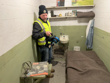
The rugged 22.5-acre site of the notorious US island prison Alcatraz has been digitally captured in a world-leading project involving multiple mapping technologies. With the team camped in the jail�...

The number of wildfires has increased dramatically in recent years due to diminishing forest health caused by the drastically changing climate across the world. Longer dry-weather periods and pressure...
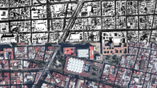
Over the past 15 years, geospatial information has enabled the transformation of towns, cities and a whole state in Mexico. The customer and data provider teamed up to create up-to-date datasets to en...

Blue Marble Geographic’s flagship software, Global Mapper Pro, is an all-in-one GIS package for analysing and processing vector, terrain, image and point cloud data. Compatible with over 380 differe...

Rapid advancements and improvements in technology have made a huge difference to surveying techniques and solutions. Such a densely populated market of devices can feel overwhelming, leaving buyers ba...

Smart Delta has entered into partnership with Cyvl.ai, combining mobile mapping experience with AI expertise. Smart Delta views this step as a powerful new opportunity to address challenges and discov...

Mobile mapping technology company Mosaic has entered into a strategic partnership with Brazilian geospatial company ARX. This marks a significant step in the efforts of Mosaic, a 360° mapping camera ...

Pix4D has launched PIX4Dcatch 2.0: a new and improved version of Pix4D’s terrestrial scanning iOS mobile app that adds professional-grade augmented reality (AR) and compatibility with a multitude of...

Airbus has launched the Pléiades Neo Next programme to expand its very high-resolution Earth observation constellation. This new programme will introduce new satellite assets and capabilities, includ...
This site uses cookies. By continuing to use this website, you agree to our Cookies Policy. Agree


